Uploads by Bethetsu
From SamuraiWiki
Jump to navigationJump to searchThis special page shows all uploaded files.
| Date | Name | Thumbnail | Size | Description |
|---|---|---|---|---|
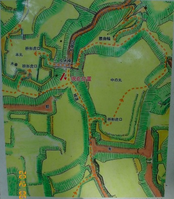
| 21:53, 3 July 2012 | Takiyama C(Musashi).layout.jpg (file) | .layout.jpg) |
88 KB | Layout of Takiyama Castle 滝山城 Hachiôji (Musashi). From pamphlet put out by Tokyo Park Commission. (Picked up June 2012.) |
| 21:50, 3 July 2012 | Takiyama C (Musashi).central layout.jpg (file) | .central_layout.jpg) |
66 KB | Central section of Takiyama Castle 滝山城 in Hachiôji (Musashi). Sign on site (June 2012) |
| 21:48, 3 July 2012 | Takiyama C (Musashi).view from.jpg (file) | .view_from.jpg) |
110 KB | View of Tama and Akigawa Rivers from honmaru of Takiyama Castle 滝山城 in Hachiôji (Musashi) Photo by Bethetsu. |
| 21:44, 3 July 2012 | Takatsuki C (Musashi).view.jpg (file) | .view.jpg) |
37 KB | Takatsuki Castle location 高月城 Hachiôji City (Musashi) (Photo by Bethetsu) |
| 01:43, 15 October 2010 | Shang.CyclicalDates.jpg (file) |  |
67 KB | An Shang-period oracle bone from the late 2nd millennium BC. The character 癸 is the big X. One can clearly see three cyclical day dates of the divination, R to L followed by 卜"divine". The dates are 癸酉、癸未、癸巳. |
| 01:39, 13 October 2010 | YearDates.jpg (file) |  |
62 KB | 1610,1712,1387,2005,1724,1418,1610 |
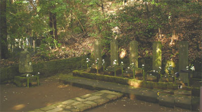
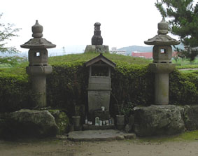
| 05:51, 22 March 2009 | Yumoto.Go-Hojo.graves.jpg (file) |  |
55 KB | Grave of the five Hôjô lords, plus Ujitsugu (far left), established in 1672 in Sôunji, Yumoto. |
| 09:10, 12 February 2009 | Hamura Seki.JPG (file) |  |
63 KB | Reverted to earlier revision |
| 08:31, 12 February 2009 | Edo.well.model.jpg (file) |  |
39 KB | The underground water system involved various technical devices. |
| 08:29, 12 February 2009 | Edo.Well.Diagram.jpg (file) |  |
76 KB | Ordinary people in Edo accessed the water brought through the waterways by wells. |
| 08:26, 12 February 2009 | Hamura.Tamagawa Josui.JPG (file) |  |
62 KB | The Tama-gawa Waterway near its source. Shortly, much of the water will be diverted to various areas as part of the Tokyo Water System. |
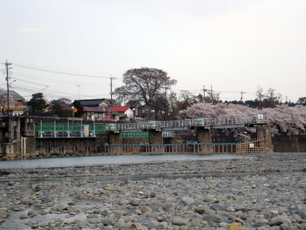
| 06:07, 12 February 2009 | Hamura Seki.jpg (file) |  |
63 KB | Hamura Weir. The gates on the left take water from the Tama River to the Tamagawa Waterway. |
| 05:45, 12 February 2009 | Inokashira.Ochanomizu.jpg (file) |  |
105 KB | Ochanomizu Spring in Inokashira Park, the source of the Kanda River. It is said Ieyasu often used water from here for tea when he was hawking near here. |
| 05:42, 12 February 2009 | Kanda Gawa.jpg (file) |  |
72 KB | The Kanda River was part of the early Edo water system |
| 23:58, 28 September 2008 | Hachioji.Matsuki view.JPG (file) |  |
111 KB | View from Matsuki Circuit (Kuruwa) On 1590/6/23 Maeda Toshiie's troops attacked and overwhelmed this circuit, which was defended by Nakayama Kageyu Ienori. |
| 03:02, 7 May 2008 | HachiojiC.honnomaru.JPG (file) |  |
247 KB | The flat top of the mountain where the hon-maru was is only about eight meters in diameter. |
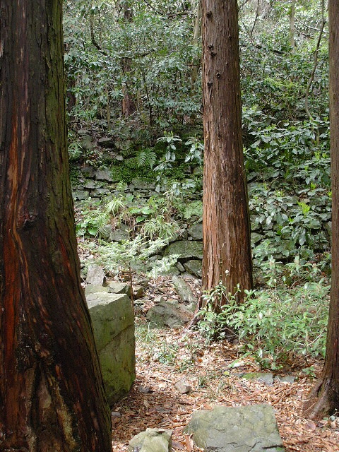
| 03:00, 7 May 2008 | HachiojiC.hillside.JPG (file) |  |
262 KB | The steep sides of the mountain were also fortified with stonework. |
| 02:58, 7 May 2008 | HachiojiC.stonework.JPG (file) |  |
207 KB | |
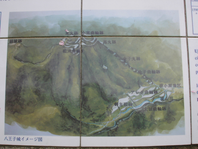
| 02:50, 7 May 2008 | HachiojiC.diagram.JPG (file) |  |
208 KB | Diagram of the castle as it was in the 16th century, viewed from the south. The approach was from the right. The residential area was at the bottom right. The Hon-maru was at the top of the mountain, with the Matsuki Circuit 松木曲輪 just below it. |
| 02:46, 7 May 2008 | HachiojiC.Shiroyama.JPG (file) |  |
212 KB | Shiroyama ("Castle Mountain") seen from the east |
| 22:14, 27 March 2008 | Yashima.fromMaejima.jpg (file) | 21 KB | Yashima, the flat-topped land in the center, seen from the NE | |
| 07:49, 23 September 2007 | Toyotomi mon.jpg (file) |  |
8 KB | Toyotomi crest from S-A list |
| 00:53, 13 September 2007 | Takamatsu(Bitchu).Mt Ishii.jpg (file) | .Mt_Ishii.jpg) |
13 KB | Mt. Ishii, where Hideyoshi's HQ were, viewed from Takamatsu Castle site |
| 00:51, 13 September 2007 | Takamatsu(Bitchu).Kubizuka.jpg (file) | .Kubizuka.jpg) |
16 KB | Burial mound for Shimizu Muneharu's head |
| 05:47, 23 July 2007 | NumataCstl.Cherry c1600.jpg (file) |  |
26 KB | Cherry tree from about 1600 on the grounds on Numata Castle. |